What Does the Urban Heat Island Effect Mean to Richmond?
Hi everyone! It's Dr. Hoffman here, the climate scientist at the Science Museum of Virginia. Let me tell you about some of the things we have been doing lately.
Last summer, the Science Museum of Virginia received a grant from the Virginia Academy of Science to work with Dr. Vivek Shandas of Portland State University, the University of Richmond, Virginia Commonwealth University, GroundworkRVA, and the City of Richmond Sustainability Office on a unique project to measure the city’s temperature in various places all at once during a heat wave. Our goal was to identify the strength of Richmond’s “urban heat island effect.”
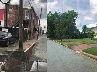
Cities like Richmond are full of hard, impervious, and dark surfaces – things like asphalt parking lots, roads, and brick buildings. Much like the feeling when you wear a dark shirt on a sunny day, these surfaces absorb and hold onto more of the sun’s energy during the morning and afternoon and then re-emit it back into the air during the night. These human-made structures physically amplify and extend heat waves!
Here in Richmond, we also lack shady trees and other vegetation in the areas where we have a lot of these impervious surfaces. This decreases the amount of evapotranspiration (basically, plants’ method of sweating like we do) going on to cool down these parts of the city. Evaporation of water is an endothermic reaction, meaning it removes energy (in this case, heat) from the environment in order to occur. This, in turn, cools the surrounding area.
Taken together these two variables – the amount of impervious surface and tree canopy – can tell us a lot about a city’s potential for a heat island effect.
This urban phenomenon, which can raise city temperatures several degrees relative to the surrounding rural areas, was first described (although not named) way back in the 1800's!
HOW DID WE MEASURE IT AND WHAT DID WE FIND?
In order to measure Richmond’s urban heat island effect, we used electronic temperature sensors and GPS units running at the same time out of our cars’ passenger side windows to keep track of where we were and how hot it was every single second. Our team of volunteers collected data at 6 am, 3pm, and 7pm for an hour each time to give us a pretty good approximation of the coolest, hottest, and early evening temperatures throughout the day. In total, we collected well over 60,000 temperature readings across the Richmond area.
In a case of classic scientific serendipity, we were fortunate to make our observations during the major heat event that occurred on July 13, 2017. With maximum air temperatures reaching 99°F at the Richmond International Airport and record-breaking average (88°F) and minimum temperatures (77°F), we had the “perfect” weather to understand how our city’s structures strengthen or reduce heat extremes.
Our results identified a ~16°F difference between the warmest and coolest places in the city during the hottest time of the day (3-4pm). As you might guess, the coolest places had lots of dense shade and plants (namely, Dogwood Dell Loop trail) while the hottest places were industrial areas with very little tree cover (Scott’s Addition, Manchester, Shockoe Bottom). Most of these places also remain at these elevated temperatures well into the evening. There are other interesting relationships between where heat accumulates in city and neighborhoods to investigate, but we’ll get into that in a follow-up blog post.
What’s especially interesting is that the hottest temperatures make a boomerang-shaped boomerang, extending from the west end of Broad Street all the way across the James River and into the south side of the city through Manchester. As it turns out, this looks a lot like two other datasets related to urban heat accumulation in cities – our tree canopy and impervious surface maps. More precisely, where we have low tree canopy and high impervious surfaces, we see high air temperatures. While this isn’t a surprise necessarily, it leads to follow-up questions. What else could be going on in these areas that may be related to extreme heat?
Believe it or not, extreme heat is the leading cause of weather-related fatalities over the last 30 years, outpacing flooding, lightning, tornadoes, and hurricanes on average. While we don’t have fatality data related to heat here in Richmond, we were able to estimate the rates of heat-related illnesses experienced per 10,000 people in Richmond area zip codes and then compare them directly to our heat island data. These data were graciously supplied by the Virginia Department of Health and the Richmond Ambulance Authority. I added the zip codes to the map so you can better identify your own.
Nope – that’s not your eye tricking you. Those datasets closely mirror one another. When separating these data into terciles – groups each containing one third of the total data – we get the same boomerang-shaped trends for zip codes with the highest temperature and heat-related illnesses.
We’re studying these data in more detail and thinking about how we might explore these data in an interactive Museum experience or gameplay.
One thing is certain. The urban heat island effect as we’ve measured closely corresponds to high rates of adverse health impacts due to heat. While it’s hard to say that something causes something else in science, the medical and climatological data are quite clear in this case.
What can we do about extreme heat? The Centers for Disease Control and Prevention has a great resource to help us in this case. Check it out below. The key is to find some shade, a cooled space like a community center or library, and drink plenty of water. The City of Richmond opens cooling centers on extreme heat days as well. Most of the time, these generally are located at the Southside Community Services Center, 4100 Hull Street Road, and the Department of Social Services, 900 E. Marshall St.
This week, I’m heading off to Washington, D.C. and Baltimore, MD to co-lead two more urban heat island campaigns like this one. I’ll keep you updated on the findings. For now, stay cool!