Science + History: Remembering the Galveston Hurricane of 1900
The Atlantic hurricane season has been relatively calm so far this year, but we’re still sharing lots of hurricane-related content right now. That’s because while the Atlantic hurricane season runs from June to November, September is the peak month for these types of storms. Sometimes when there isn’t as much tropical storm activity, it’s easy to forget how devastating hurricanes can be and how much we have come to rely on science to help us track, monitor and prepare for hurricanes.
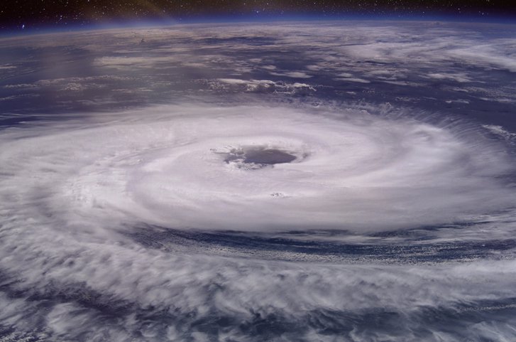
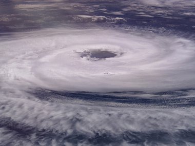
Many who live in coastal areas are very accustomed to hearing about the forecast cone, which the National Weather Service produces to estimate the “track,” or path, a storm may take. The science behind predicting these tracks grows more sophisticated all the time, and can provide valuable warning time for people to evacuate areas that may be most affected.
Today, the three-day advanced predictions of hurricane paths are more accurate than 24-hour forecasts were in the 1970s and 1980s. When it comes to extreme weather events, giving communities more time to prepare (and in some cases evacuate) can drastically reduce the impact a storm may have. Thank you, science!
This month 122 years ago, the Galveston Island hurricane showed just how devastating a lack of forewarning can be when a hurricane strikes.
In 1900, Galveston, Texas, was one of the most prosperous cities in the United States. The highest ground on Galveston Island was just under 9 feet above sea level, but proposals for a seawall were never implemented because while the area had experienced hurricanes before, the city had never been seriously damaged.
Scientists at the United States Weather Bureau (the future National Weather Service) in Washington knew there was a storm in the Caribbean that had passed through Cuba on September 3, but because earlier storms had turned east toward Florida after moving on a northwest trajectory out of the Caribbean, they predicted this one would, too. The main effect, they predicted, would be felt along the Atlantic seaboard, including possibly Virginia, as the storm moved northeast. Most importantly, they believed this was just a tropical storm, not a hurricane.
“The story of Galveston's tragedy can never be written as it is…for the thousands of tragedies written by the storm must forever remain mysteries until eternity shall reveal all. Perhaps it were best that it should be so, for the horror and anguish of those fatal and fateful hours were mercifully lost in the screaming tempest and buried forever beneath the raging billows.”
-The Galveston Daily News, September 13, 1900
Because of the belief that the storm would track northeast, Isaac Cline, the Weather Bureau’s chief observer in Galveston, received no storm warning. Even more unfortunate is that scientists in Cuba understood what the storm was likely to do, but the Weather Bureau had banned reports from Cuba, cutting off vital information that could have provided more warning for the Gulf Coast.
On the morning of September 7, the Weather Bureau in Washington realized the storm was not where they thought it was supposed to be. Instead of moving up the East Coast, it was still in the Gulf of Mexico. The Bureau ordered Cline to raise the storm flag in Galveston, but it was too late.
The storm would turn out to be a Category 4 hurricane by the time it reached Galveston. By early morning on September 8, the storm surge began to cover the island and winds would eventually reach approximately 140 miles per hour. During the night, the storm surge would reach as high as 15 feet, completely covering the entire island and pushing a wall of debris in front of it as it went.
The destruction in Galveston was nearly total, with every bridge onto the island and most of the buildings wrecked. The exact number of casualties is unknown, but it is estimated as many as 6,000 people were killed. To this day, the Galveston Hurricane of 1900 is widely considered the deadliest natural disaster in US history.
Today, decades of data and advanced technology have led to greatly improved hurricane predictions. Though hurricanes and other larger storms have increased in frequency, duration and intensity due to the effects of climate change, meteorologists are able to provide much more timely warnings to people likely to be affected by severe weather events, allowing crucial evacuation time. The number one goal is always to prevent another human tragedy like the 1900 Galveston Hurricane.
And just because this tragedy took place in the Gulf Coast, and hurricanes make landfall more often in Florida and Texas–both thousands of miles away from Virginia–this doesn’t mean our state hasn’t seen its share of storms. From Hurricane Gracie in 1959 to Hurricane Florence in 2018, and with Hugo, Floyd, Dennis, Fran, Cleao and Ernesto in between, September has proven to be a high-impact month in Virginia. In fact, the most devastating hurricane to make landfall in our state in recent memory was Isabel in September 2003. That Category 1 storm contributed to 32 deaths in the state and damaged nearly 120,000 homes and businesses, resulting in a $1.85 billion total loss.
As we said at the beginning, even without budding hurricanes brewing in the Atlantic right now, those historical events are enough of a reminder that the time to prepare for storms is now. And looking back at what happened before we had early warning systems is a great way to remember that continued investment in scientific advancements is key to keeping our communities informed and safe.